
Meteorologists are warning of a potentially dangerous multiday storm event across the central U.S. this week.
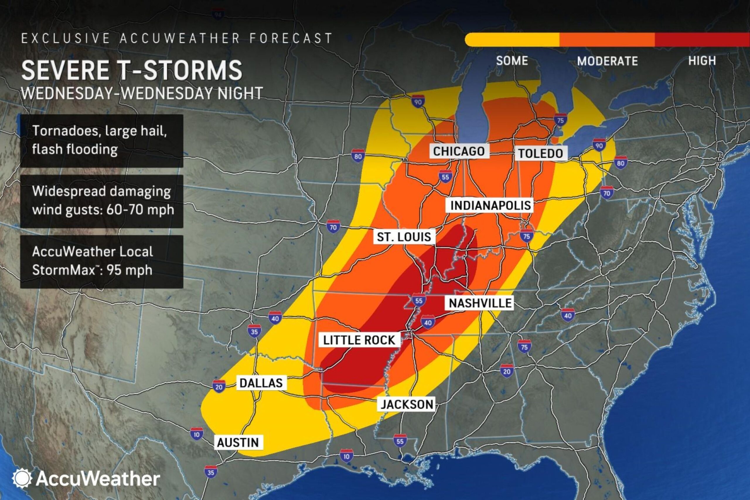
On Wednesday, a large area from Texas to the Midwest is under a high risk of severe thunderstorms, including the possibility of tornadoes, large hail, damaging winds and life-threatening flash flooding.
Why It Matters
The storm threat follows a weekend system that killed at least two people and produced large hail and multiple tornadoes. With forecasts now calling for more than a foot of rain in some areas, experts say this week’s weather pattern could trigger generational rainfall across eastern Arkansas, north Mississippi, west Tennessee, and southeast Missouri.
What To Know
According to AccuWeather meteorologists, another round of storms could hit on Wednesday.
AccuWeather
The outlet identified a high-risk zone for severe thunderstorms covering parts of Arkansas, western Tennessee, southeastern Missouri, southwestern Indiana, southeastern Illinois, and western Kentucky.
The National Oceanic and Atmospheric Administration’s Storm Prediction Center (SPC) outlook for Wednesday confirms an enhanced risk area stretching from extreme northeast Texas and northern Louisiana through Arkansas, Mississippi, Missouri, and into Illinois, Indiana, Kentucky and western Ohio.
The potential for tornadoes, damaging winds, and flash flooding are forecast throughout the region.
AccuWeather meteorologists say some areas could see damaging wind gusts of 60 to 70 miles per hour would be possible by late Wednesday night.
What People Are Saying
AccuWeather meteorologist Brandon Buckingham, in an advisory note provided to Newsweek: “There is the risk of multiple strong tornadoes to form near the Texas-Arkansas border to perhaps as far north as portions of southern Illinois and central Indiana beginning Wednesday afternoon and continuing into Wednesday night.”
AccuWeather meteorologist Bernie Rayno, in the same advisory: “This is a huge area facing a risk of severe weather spanning from Texas all the way to Michigan. We could see two dozen tornadoes or more on Wednesday. The risk for tornadoes will extend well into the late-night hours.”
Rayno added: “Widespread warmth with temperatures you’d typically see in mid-May is a troubling sign for severe weather.”
The NOAA SPC said in its outlook for Wednesday: “Numerous severe storms are likely Wednesday and Wednesday night across the Lower Great Lakes, Mid Mississippi Valley, and the ArkLaTex. Severe wind gusts, very large hail, and strong tornadoes are possible.”
What Happens Next
Forecasts are subject to change. Those in affected areas are advised to monitor local forecasts and updates.
AccuWeather’s long-range 2025 U.S. Severe Weather Forecast projects between 1,300 and 1,450 tornadoes nationwide this year, with most of the activity expected east of the traditional Tornado Alley.