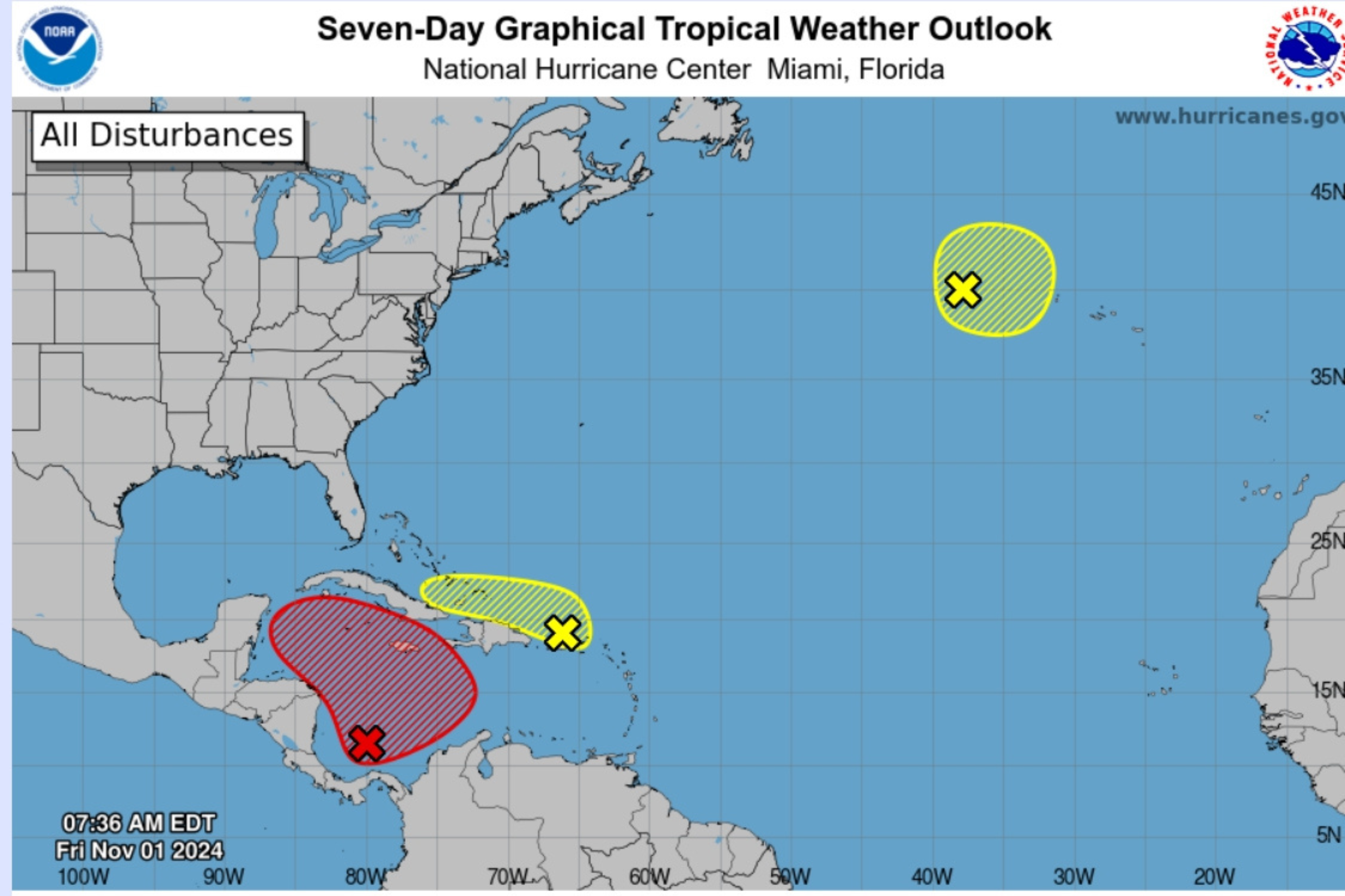
The National Hurricane Center (NHC) is monitoring three areas of storm development, all of which have a low possibility of forming at the same time within the next two days.
Over the past week, NHC meteorologists have been monitoring a system in the Caribbean Sea that has growing potential to strengthen into Tropical Storm Patty. The storm’s path, should it form, is still unclear, though there’s a chance that it could take aim at Florida, which recently battled two, back-to-back major hurricanes, Hurricane Helene in late September and Hurricane Milton in early October.
As of Friday morning, the NHC is monitoring two new systems—one in the northeastern Caribbean and one in the north Atlantic.
Of the three systems, the southwestern Caribbean one has the highest chance of development, with a 30 percent chance of strengthening within the next two days and a 70 percent chance in the next seven days.
National Hurricane Center
The other two systems each have a 10 percent chance of strengthening.
“We continue to monitor multiple areas for tropical development,” the NHC posted on X, (formerly Twitter) on Friday morning. “In particular an area in the SW Caribbean has a high (70%) chance of development, a broad area of low pressure is expected to develop and a tropical depression is likely to form late this weekend or early next week.”
Newsweek reached out to the NHC by email for comment.
System in the Southwestern Caribbean
AccuWeather forecasters have shifted the expected dates for development of this system, given its slow progress. It was originally expected to form in late October, and meteorologists now anticipate it could form Friday or Saturday.
“A broad area of low pressure is likely to develop over the southwestern Caribbean Sea during the next day or so,” the most recent NHC forecast said.
“Gradual development is possible thereafter, and a tropical depression is likely to form late this weekend or early next week while the system drifts generally northward or northwestward over the central or western Caribbean Sea. Regardless of development, locally heavy rains are possible over portions of the adjacent land areas of the western Caribbean,” the forecast said.
System in the Northeastern Caribbean
A widespread area of rain showers and thunderstorms is occurring near the Greater Antilles and surrounding waters, the NHC said. The system has an equal chance of developing in 48 hours or seven days, at 10 percent.
“Slow development of this system is possible during the next few days as it moves west-northwestward near the Greater Antilles,” the NHC forecast said.
“After that time, this system is expected to be absorbed into the low pressure area over the Caribbean. Regardless of development, locally heavy rains are possible during the next several days from the northern Leeward Islands westward across Puerto Rico and Hispaniola to eastern Cuba and the southeastern Bahamas,” according to the forecast.
System in the North Atlantic
This system has equally low chances of development, at 10 percent.
“A storm-force non-tropical low pressure area located about 400 miles west of the western Azores is producing limited shower activity,” the NHC forecast said. “Some subtropical development is possible while the low moves generally eastward during the next few days.”
If this system continues its trek eastward, it would have no impact on the U.S.
Should three tropical storms develop simultaneously, they will be named Patty, Rafael and Sara.
There is still a month left in the 2024 Atlantic hurricane season, which runs through November 30.
