
Numerous states along the United States Eastern Seaboard are anticipating torrential rain and other impacts this week as National Hurricane Center (NHC) meteorologists monitor a disturbance off the East Coast that could strengthen into Tropical Storm Erin by the end of the week.
Why It Matters
The NHC is currently tracking three systems in the Atlantic Ocean: Tropical Storm Dexter, which is currently moving further out to sea, and two disturbances, one in the central tropical Atlantic and one brewing much closer to the U.S. Each of these disturbances has a moderate chance at strengthening into a tropical storm in the coming days.
Even if the system closest to the U.S. doesn’t strengthen into a tropical storm, it is still expected to bring tropical rain and wind impacts to at least two states.
What To Know
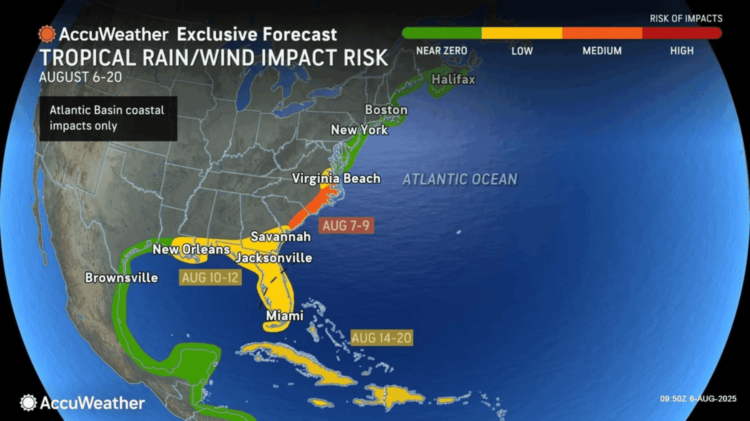
This week, AccuWeather shared a map showing the risk of tropical impacts over the coming days. The coasts of South Carolina and North Carolina faced a medium risk of tropical rain and wind in the coming days, the highest of the Eastern Seaboard. The Virginia coast faces a low risk, whereas Maryland north through Maine faces a near-zero risk.
AccuWeather
AccuWeather Lead Hurricane Expert Alex DaSilva told Newsweek that the system off the Southeast coast originally looked as though it could curve toward the U.S., but now looks as though it will run parallel to the coast.
Despite moving inland, a wet pattern accompanied by thunderstorms is still expected across the Southeast to end this week. AccuWeather is forecasting additional heavy rain across the Southeast, including states like South Carolina and North Carolina, areas that have already seen several inches of rainfall this month.
Further south, Georgia and Florida face a low risk. Louisiana, Alabama and Mississippi face a low risk of such impacts from a separate system in the Gulf monitored by AccuWeather meteorologists that could evolve between August 10 and 12.
Weather experts have issued repeated warnings this summer that peak Atlantic hurricane season doesn’t typically hit until September, urging people to take precautionary action, such as stocking up on emergency supplies and ensuring they have proper insurance in place, before a storm forms.
The National Oceanic and Atmospheric Administration (NOAA) is predicting from 13 to 19 named storms for this year’s Atlantic hurricane season, with six to 10 strengthening into hurricanes and three to five into major hurricanes.
What People Are Saying
AccuWeather Lead Hurricane Expert Alex DaSilva told Newsweek: “In terms of thunderstorm activity, there’s not a whole lot going on, but I think that’s going to change here in the next day or so. It still looks like it’s going to be a wet pattern overall across the Southeast through late week, especially closer to the coast.”
The NHC in its most recent update about the disturbance closest to the Southeastern U.S.: “A weak area of low pressure has formed from a surface trough, several hundred miles off the coast of the southeastern United States. However, this system is currently producing only limited shower and thunderstorm activity and development is likely to be slow to occur during the next few days. Thereafter, environmental conditions could become a little more conducive for development. A tropical depression could still form by this weekend as the low initially drifts westward before turning northward to northeastward by the weekend.”
What Happens Next
The disturbance closest to the U.S. has a 10 percent chance of strengthening into a tropical storm in the next 48 hours. It has a 40 percent chance of doing so in the next seven days. NHC officials will continue to monitor the system, although there are no hurricane or tropical storm alerts in place for the U.S. as of Wednesday morning.