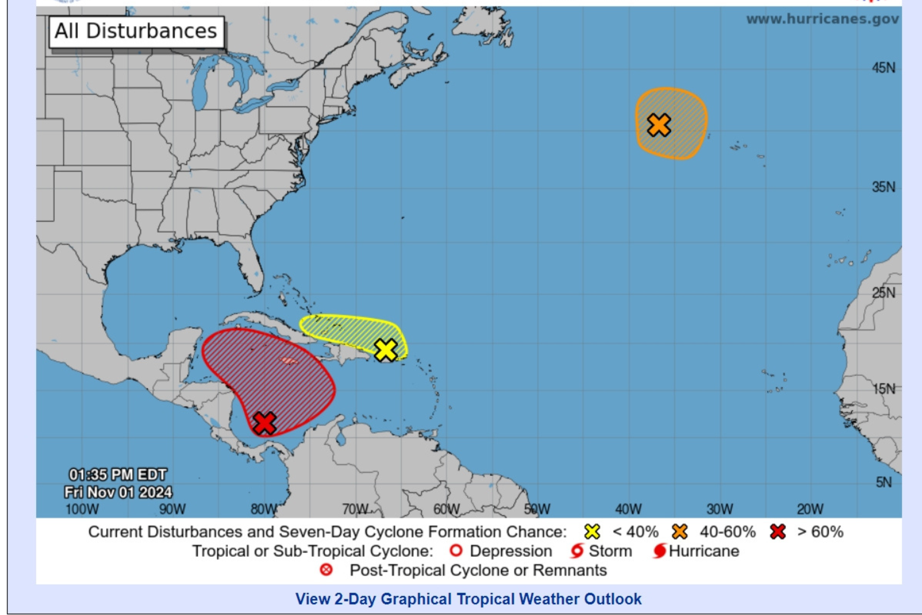
Chances that a system in the north Atlantic monitored by the National Hurricane Center (NHC) will strengthen into a tropical storm in the next few days have escalated to 40 percent.
On Friday morning, the NHC began monitoring two additional systems in the Atlantic Ocean as well as the slowly strengthening one in the southwestern Caribbean Sea, which it has been watching for about a week. The two new systems had a low chance of formation in the next 48 hours, at only 10 percent, but that chance has since quadrupled to 40 percent for the northern system in only seven hours.
“A low pressure system located a few hundred miles west of the Azores has been producing increased convection near its center over the past few hours. Earlier satellite derived wind data depicted winds to storm-force mainly to the south of the center,” read the most recent NHC forecast, issued at 2 p.m. Eastern time Friday. “Environmental conditions appear favorable for some additional development and the system could become a subtropical or tropical storm as it moves generally eastward during the next few days.”
Newsweek reached out to the NHC via email for comment.
National Hurricane Center
The forecasts added that interests in the Azores should monitor the system’s progress.
If a tropical storm forms, it won’t impact the U.S., as its path will take it further east.
However, there are two systems with a chance at forming in the Caribbean Sea that could impact the States.
The system in the southwestern Caribbean has shown increasing chances of forming into Tropical Storm Patty as the week progressed. As of Friday afternoon, the system had a 30 percent chance of developing within the next two days, and a 70 percent chance within the next week. Although an official path has yet to be published, the storm is showing chances of trekking toward Florida, which recently battled back-to-back major storms with Hurricane Helene in late September and Hurricane Milton in early October.
The system in the northeast Caribbean Sea is less likely to form, given higher wind shear near the Bahamas that could tear the storm apart, AccuWeather reported, though the system could produce locally heavy rain.
“Slow development of this system is possible during the next few days as it moves west-northwestward near the Greater Antilles,” the NHC forecast said. “After that time, this system is expected to be absorbed into the low pressure area over the Caribbean. Regardless of development, locally heavy rains are possible during the next several days from the northern Leeward Islands westward across Puerto Rico and Hispaniola to eastern Cuba and the southeastern Bahamas.”
All three systems are showing potential of formation within the next few days, meaning three tropical storms could be churning in the Atlantic Ocean at the same time this weekend or early next week. The next three tropical storms will be named Patty, Rafael and Sara.
